Lighthouse · Annapolis, Maryland
Bloody Point Bar Lighthouse
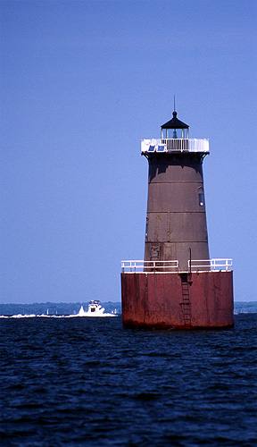
The tower, first lit in 1882, is dark now. The working light, one white flash every 6 seconds, stands nearby, about 140 m away. It is listed on the National Register of Historic Places. A leaning iron sparkplug tower off the south end of Kent Island, gutted by fire in 1960 and privately owned since 2006; it is dark now, and a warning light on piles beside it marks it.
Open in the viewer from Muskrat Park, St. Michaels →
Quick facts
| Type | Lighthouse |
|---|---|
| Built | 1882 |
| Light | Fl W 6s |
| Position | 38.8336°N, 76.3917°W |
| From Muskrat Park, St. Michaels | 16 km (9.7 mi), bearing 290° WNW |
| Source | NOAA ENC; OpenStreetMap; National Register 02001416 |
How to see it
Above water and inside the horizon from Muskrat Park, St. Michaels, 16 km (9.7 mi) away, so on a clear day it can be seen from there, and CoastFinder puts a label on it.
On the website for now. Maryland's lighthouses are in the web viewer first, and they are coming to the CoastFinder app, which covers the North Carolina coast today. Follow @coastfinderapp to hear when Maryland arrives.
Nearby
- Thomas Point Shoal LighthouseLighthouse · 8.2 km
- Hooper Strait LighthouseLighthouse · 16 km
- Sandy Point Shoal LighthouseLighthouse · 20 km
- Sharps Island LighthouseLighthouse · 22 km
- Baltimore LighthouseLighthouse · 25 km
- Craighill Channel Lower Range Front LightLighthouse · 39 km
Not for navigation. Positions and depths come from public charts and records, with their sources named above; they are for looking, not for piloting a boat.