Lighthouse · Cape Lookout, North Carolina
Cape Lookout Lighthouse
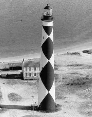
The 163 ft (50 m) tower was lit in 1859 and became the pattern for the later Hatteras, Bodie and Currituck lights. Its black-and-white diamond daymark (painted in 1873) is oriented so the black diamonds point north-south, a navigational hint for mariners. The light flashes white every 15 seconds and anchors the southern end of Cape Lookout National Seashore.
Open in the viewer from Cape Lookout Point →
Quick facts
| Type | Lighthouse |
|---|---|
| Built | 1859 |
| Height | 50 m (164 ft) |
| Light | Fl W 15s |
| Position | 34.6228°N, 76.5245°W |
| From Cape Lookout Point | 3.3 km (2.0 mi), bearing 9° N |
| Source | NOAA ENC US5MRHCD; Curated (NOAA AWOIS / NC DMF / NPS) |
How to see it
Above water and inside the horizon from Cape Lookout Point, 3.3 km (2.0 mi) away, so on a clear day it can be seen from there, and CoastFinder puts a label on it.
Further reading: Cape Lookout Lighthouse on Wikipedia.
Point your phone at the real thing. The CoastFinder app draws this lighthouse over your live camera view from any beach, pier or boat near Cape Lookout, with its distance and height, and it works with no signal.
Nearby
- Capt Charley LewisShipwreck · 1.2 m · 7.0 km
- ThistleroyShipwreck · 1.2 m · 7.2 km
- Harkers IslandIsland · 8.7 km
- Senateur DuhamelShipwreck · 14.9 m · 11 km
- VerbenaShipwreck · 18.8 m · 11 km
- George Summerlin Reef (AR-285)Reef · 18.8 m · 11 km
Not for navigation. Positions and depths come from public charts and records, with their sources named above; they are for looking, not for piloting a boat.