Lighthouse · Cape Fear, North Carolina
Frying Pan Shoals Light Tower
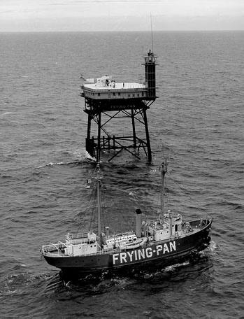
A steel platform on four legs, like an oil rig, standing in open sea at the end of Frying Pan Shoals, about 30 miles off Cape Fear. Completed in 1964 and lit in 1966, it replaced the lightship that had marked the shoals since 1854. The Coast Guard automated it in 1979 and discontinued the light in 2003. Sold at auction in 2010, it has been privately owned since, occasionally run as a bed and breakfast, and its web camera is a fixture of hurricane season.
Open in the viewer from Cape Fear point, Bald Head Island →
Quick facts
| Type | Lighthouse |
|---|---|
| Built | 1964 |
| Height | 40 m (131 ft) |
| Position | 33.4832°N, 77.5835°W |
| From Cape Fear point, Bald Head Island | 53 km (33 mi), bearing 139° SE |
| Source | OpenStreetMap; Curated (SC DNR / NC DMF / dive references) |
How to see it
Above water but beyond the horizon from Cape Fear point, Bald Head Island, 53 km (33 mi) away: the curve of the earth hides it. CoastFinder draws it faintly and marks it hidden, with its bearing and distance.
Further reading: Frying Pan Shoals Light on Wikipedia.
Point your phone at the real thing. The CoastFinder app draws this lighthouse over your live camera view from any beach, pier or boat near Cape Fear, with its distance and height, and it works with no signal.
Nearby
- Capt. Greg MicKeyShipwreck · 19.2 m · 710 m
- AR-400 artificial reefReef · 19.2 m · 1.7 km
- Frying Pan ShoalsShoal · 10 m · 14 km
- City Of HoustonShipwreck · 20.3 m · 15 km
- George WeemsShipwreck · 10 m · 18 km
- RosinShipwreck · 25.9 m · 22 km
Not for navigation. Positions and depths come from public charts and records, with their sources named above; they are for looking, not for piloting a boat.